Well, it seems we are going to spend a few more days around this area until the fifth gear comes next week (see previous post). The Pyrenees are only a couple of hours drive away and we fancy a days skiing, but tomorrow is Saturday, the slopes will probably get quite busy, so better leave the skiing for Monday. So what should we do around here over the weekend?
There is a national park called Montseny with spectacular and numerous walks to choose from. We pop in the tourist information office in Arubices and buy the walking map. The three highest peaks: Matagalls (1696m), Turo de l’Homme (1706m) and Les Agudes (1706m) are very close to each other and the climb starts not far from here. It looks like we can fit the first one in this afternoon.
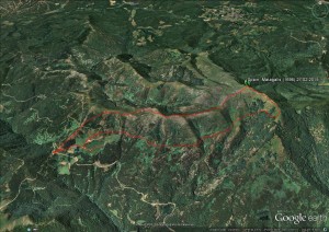
The trek to Matagalls starts in Coll Formic, a pass close to el Brull village, 30 kms from Arbucies. It is 12.00. We drive quickly up there, have a quick lunch and start the trek at 15.00.
We leave Dora in the car park at the pass, cross the road and go up the steps. The route up to the peak follows the GR 5.2, clearly marked with red and green slashes. We soon find the marks at the beginning of the steps.
 (640x480)")
So the navigation should be quite easy. We may have not needed to buy the walking map. It will be useful though, to practise identifying tracks, peaks, contour lines and if we want to go off piste to practise a bit of navigation, which we may do today on the way back, we have still four hours of daylight.
 (640x480)")
The way up we are quite slow. Gary is suffering of a mild backache. He must have twisted one of his muscles when trying to lift the table inside Dora to clean the floor. Better be careful! We don’t want to be too unhealthy when we travel. Dora is not precisely the best place to rest and recover.
 (640x480)")
We climb steeply and gain height quickly. The landscape opens up to an incredibly view. Towards the north, snowy peaks. Are they the Pyrenees? They look so close. We cannot work it out from our map.
We look around to work out our route. A farm sits below us down the valley. Next to it, a track joins the GR5.2 which goes back to the car park. This farm is where we should be aiming at on our way back.
 (640x480)")
A cow comes to say hello. She must live on the farm. She has travelled a long way up!
 (640x480)")
We are trying to work out which peak we are climbing. Maybe it is behind this one?
 (640x480)")
After 45 minutes, we reach the plateau, a spot highly recommended by the guide for a lunch with superb views. Shame we’ve already had ours. So no stop for us.
 (640x480)")
We start to see our summit, slightly off to the left. According to the guide, it should only be 30 minutes from here. It looks further. Not surprising, we have been climbing at a fairly slow pace. However, Gary is now energetic. “Come on, let’s hurry up” he suddenly says.
 (640x480)")
It is getting misty further east. We look at the map. Those must be the mountains which we are climbing tomorrow. We can hardly see them now.
 (640x480)")
In half an hour, we finally reach the summit. We made it!
Of course, the mandatory cross and, bizarrely, a nativity at the base, with all the sculptures in place. I am amazed they have resisted the winds, god must have something to do with it ![]()
 (640x480)")
A lonely cloud quickly flies over us.
 (640x480)")
We take also a mandatory photo. We hope the strong winds don’t take the camera away!
 (640x480)")
Time to get back.The path follows the ridge, first and then south. Snow which has fallen over the last couple of days still exists. Although not that high, it is pretty windy and chilly here.
 (640x480)")
The path is not that clear now but we are constantly checking the map, the contour lines and the compass. We are pretty sure we are walking in the right direction.
 (640x480)")
A path joins us from the left. Check the map, look back, yes, this makes sense.
 (640x480)")
We are now walking through woods. It is okay for variety but a bit boring after a while.
 (640x480)")
The landscape is opening up. As we have been playing around with directions, we have gone slightly off piste. In the distance, we spot the farm we saw earlier. We are on the right track. Although to reach it, we will have to fight a few dry bushes.
 (640x480)")
A nice three hour walk. We now driving to the Sant Celoni, the nearest village before we attempt the two peaks tomorrow.
SM


No hay mal que por bien no venga,se suele decir, habéis tenido el problema de Dora, pero así tenéis más tiempo de hacer lo que os gusta, subir montañas, y divisar paisajes, a cual más bonito.
Como resisten las esculturas al viento, deben estar muy bien hechas .
Viajando tambien pasan cosas. tuvo un final feliz