We left Spain and headed off to south Portugal to walk around the Algarve. We drove directly to the South West to do three walks Julie described in her book.
In these three walks, we are giving you a few examples of why we think this woman’s walking guide is so crap – refer to our previous post where we gave you a review of this guide – .
Walk No 2 in the guide: Pontal, Carrapateira and Vilarinha
We park in Carrapateira, in an aire in front of the sea. The aire is pretty basic, just a car park, but it has stunning views to the beach. It is packed with motorhomes, mainly Germans and French. Motorhomes love their beaches.
We are quite pleased we are back on the coast. The weather is still warm. Even in the wintery, cold waters of the Atlantic we may be brave enough to take the canoes out if we continue to enjoy these temperatures.
We can’t go to bed before we go down to the beach to watch the sunset.
A star shines bright to the west, or is it a planet. Must learn more about the night skies. GDR
 (640x480)")
Now it is time to go back to Dora, it is getting cold and we have a five hour walk tomorrow. We better go to bed soon so we can get up early.
We wake bright and energetic, looking forward to our ‘serious’ coastal walk. The weather is not so nice this morning. Quite blustery with intermittent showers and a slightly cold wind. However, the scenery looks amazing. We feel we will have nice views. However, the waves are a bit violent. Maybe the kayaking will have to wait, launching in these conditions could get quite messy.
The place is infested with motorhomes. More must have arrived after us last night. Dora is going to have lots of friends today.
 (640x480)")
According to the description the path initially takes us away from the sea. The path is actually a 4×4 track. OK, we are no fans of these tracks. Because they are used by vehicles they don’t tend to go through interesting and unspoilt landscapes. Anyway, the path may change later on, so let’s wait and see.
 (640x475)")
We continue to walk up, through mild undulated and green landscapes with lots of rounded hills surrounding us. Yeap! quite different from the sort of adventurous walks we tend to do. Gary starts to spot little tiny birds, he is finding interesting things to focus his mind on. These birds will keep him entertaining from an already tedious start of the walk.
For the time being, the path seems to be marked with blue and green marks. These blue and green marks relate to the short version of the walk which runs only from the village of Carrapateira to the beach and back again, it is meant to be only two hours. Julie also describes this walk. We have decided to go for the long one.
 (640x458)")
The 4×4 track meanders endless through a wood of eucalyptus trees to reach a junction. We like eucalyptus trees. They grow tall and majestic. Their trunks peels away in large and thin strips of woods displaying different tones of brown. Besides, they expel a nice, fresh, mint smell that gets stronger when it rains, which is the case of this morning. We take deep breaths as we walk along these woods to delight our nostrils with this clean aroma.
 (640x480)")
The left track belongs to the short walk, so we should turn right, still on a 4×4 track. Damn!
 (640x473)")
We are back into open landscapes. Soon after we get into another wood, this time, pine trees.
 (640x480)")
We continue to go high, very steadily so we can expect a nice view as we get to the top of these little hills. From here though, you can get a little glimpse of the view to the coast.
 (640x473)")
Just after leaving the pine tress we bump into a ruin, which is not mentioned in the description. This is one of our critic in our previous post. She misses important and permanent way-marks that could help walkers reassure that they are on the right track, it is also not shown on the map.
 (640x480)")
The road is really windy, sometimes going to the sea and other times to the opposite direction. It carries on turning right and left, right and left… We continue to walk through pine tree woods, more pines trees, more pines trees, more pines trees….We are getting incredibly bored. We might as well have brought some cards so we could play a few games on the way.
The track is now relentlessly flat. I find walking on this type of surfaces really tiring. You hardly change your body position which means you keep on using the same group of muscles, making you really achy, it is like walking around a shopping mall.
We reach the main road and it seems we must walk down it, towards the north. Soon after after, another relentless track like the last, starts on the right The track is hardly challenging. It is starting to rain. We don’t like walking in the rain, but this time, we are glad, it might spice the walk up.
 (640x472)")
The road starts to drop into the valley after a sharp right hand turn. The track abandons the pine trees to give way to a series of meadows. A change, wow!!
 (640x480)")
The track winds down to a valley. The path splits. Ahead it continues to a cluster of farms. Left, a more rural track takes us back to the coast. We look forward to those coastal views.
Julie says the track is directing us towards a stables, we see nothing. Lets hope it’s this way.
 (640x480)")
A couple of horses come to say hello and are probably looking for some food. “Sorry guys we have nothing for you”.
 (640x480)")
The path continues, continues, continues, straight ahead. We can now see a glimpse of the coast line on the horizon.
 (640x480)")
And now, a main road. Our path crosses over it and goes through a few houses and restaurants, not very pretty, not very beautiful as it heads towards the beach.
 (640x479)")
We are getting close to the beach, you can tell as the path is getting very, very sandy. We go up to a set of picnic tables on the cliff. This area seems to be the perfect place for lunch.
The wind is very strong, the waves crash against the beach with the full force of the Atlantic. Incredibly beautiful. This is why it is worthwhile traveling at this time of the year, to enjoy beautiful places completely isolated, not a soul, just us.
 (640x480)")
From here on, we have not bothered to take any more photos, as the path goes back to a 4×4 track getting away from the cliffs.
We have been generally very disappointing. During most of the walk, the paths go around unchanging and monotonous landscapes. The coastal path, the one we were so looking forward to, runs very far away from the cliffs, so you miss the beauty and the wildness of the ocean. She, however, recommends this walk for its spectacular scenery and rolling countryside![]()
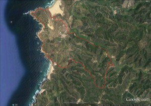
This is the map of today’s walk
Walk No 15 in the guide: Benagil to Vale de Engenho
Today we have got up early to do another long walk but the weather is pretty miserable. So we have decided to look for a Wi-Fi place for a bit of IT. Fortunately, the day has cleared. As it is already 13.00, we have chosen a short walk along another bit of the coast. This time, south, around Benagil village. This walk is meant to be only three hours.
We have been disappointed with the Algarve so far with both the quality of the walks and the impact that tourism has had on the area. But this walk is meant to be, according to Julie, a dramatic cliff walk, and one of the most picturesque one, often featured on postcards. Ok, let’s give it another chance.
We start in the village of Benagil. Going down along the main road, we pump in to a restaurant with a few stone steps on the side. We climb up them.
 (640x465)")
Soon we get to enjoy scenic views of the coastline and a beach where you can only access it by boat. Maybe we could take the canoes out tomorrow if the weather keeps like this.
 (640x480)")
Nice little gullies all the way. The sound of the ocean going through them is tremendously intimidating.
 (640x480)")
The geology of this place is absolutely fascinating and incredibly varied. Once, you are walking on limestone, five minutes later you are walking on soft rock, similar to chalk but with an amazing deep red colour.
 (640x480)")
We find a series of shellfish encrusted within the rocks: clams, cockles, scallops which look like they are on their way to becoming fossils.
 (640x480)")
The effect of erosion is remarkable. These islets are the remaining of the cliffs that have been falling into the sea. Yeap!, this image deserves a postcard.
 (640x480)")
This arch will probably collapse soon, leaving another islet sticking out of the sea, a stack.
 (640x477)")
We get to a parking area, full of motorhomes. The Algarve looks like it is one of the preferred destinations for motorhomers.
 (640x474)")
We have now reached the end of our walk, a battleship rock, although it looks more like a submarine, if you ask me. Gosh, nature makes randomly wonderful things .
At this point, we turn back.
 (640x477)")
We look at the clock, it should have taken us 1.5 hours, according to the author. But not, it has taken us 2 hours. It doesn’t make any sense. This means that the walk will take us 4 hours rather than three. If this is the case, she has not been very consistent with her timings. Yesterday’s walk took us one hour less than she suggested and today, one hour more??
It is incredibly important that a walker guide gets its timings right so that walkers are able to finish their walks in daylight. This is another critic we highlighted in our post.
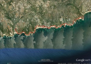
The map of today’s walk:
Walk No 16 in the guide: Amorosa-Torre Hill Walk
According to Julie, this area is meant to be characterised by fascinating and abrupt change of scenery and a complete contrast in vegetation. Well, let’s see if this is true.
At this point in time, we start to appreciate that we don’t seem to talk the same language when describing landscapes, severity of the routes and timings. As far as we are concern, she should be earning her living doing something else, she has no future writing walking books.
Or at least get someone to check her routes and qualify her directions. Also, she would benefit from reading other guides, to see the language and conventions that they use. GDR
We started our walk at 1.40 pm from the village of Amorosa and we are already having difficulty in finding the starting point.
She doesn’t really mention obvious and permanent references points that could have helped us assess whether we are on the right path. For instance, we are finding ourselves at this turning point in the photo below. So far, she has only said “turn right and then left and the right again”. Firstly, we have seen more roads turning off either side than she has actually mentioned. We have passed a school, she could have mentioned it or maybe giving a name of a road?. How useful that would have been to us.
Bizarrely it is only by looking at the description of an adjacent walk, and comparing this to the one we are trying that we get to learn of the school. What a convoluted way of determining where you are. Buck your ideas up Julie. GDR
So, this is the turning point, where do we bloody turn off to![]() ??
??
")
The approach we have taken? We read her description a bit further on and then turn right first. Nope, we can’t see any of the features she mentions, let’s go back and turn left.
Yes, that’s it. It was left. We know because she has actually mentioned the name of this house: ‘Casa Espinho’. But if she had said ‘turn left’ before that we would have saved fifteen minutes. She is so crap! Her next description, turn at the house with a rubbish bin outside it!!!!! Anyway, let’s put that behind us and press on, should we?
")
Gradually, the road meanders its way out of the village. We pass some olive and pine trees.
")
On our left hand side, the landscape opens up to a range of nice little rolling hills – sorry, she would have called those mountains! –.
")
We are still enjoying this type of countryside landscape. It contrasts dramatically with the holiday resorts stuff down on the coast.
A few villages and houses are scattered over the countryside. Some farmers seem to still be using farming methods of those back in the 1950’s.
")
One of the thing we have noticed, the amount of angry barking dogs along the farms we pass close to. They seem to be incredibly annoyed with us. Good that they are either chained or being kept behind fences. We have found a useful technique to shut them up. Bend down and grab a stone as if you we were going to throw it at them. They shrink instantly, turn back and stop barking. Remember this tip if you ever walk in the Algarve. It is worth it!
It would seem the local children’s sport, lobbing stones at dogs! GDR
We continue to walk along the road and we should be reaching Cortes, a nice, unspoilt little village. Its houses have not been refurbished for some time. We come across a few old people tidying up outside their houses, some weeding, others sweeping, slowly, no hurry, there is not a great deal to do after this task.
It is interesting. This is the sixth time I have been in Portugal, the first time thirty years ago. Back then, the country seemed to be fifteen years behind Spain. Thirty years on and the gap doesn’t not appeared to have narrowed.
")
We take a few more photos of this precious and quiet village. It has caught our attention because of its simplicity and honesty. It is a rural, small little village, not that sort of tacky place created for tourists.
")
")
We are gradually getting out of Cortes and we are now starting to get into trouble. Lovely Julie tells us after a kilometer we should see a track off to the right. Damn, I forgot to bring my pedometer. Also the description says before heading uphill. We have been walking 20 minutes, we don’t seem to be climbing. However, if we really think about it, yes we may be going up, but it is so subtle, though. Is this then what she means by going up? Our frustration with this woman continues.
")
We are going backwards, we cannot see the turning off point to the right. We find a 4×4 track which meanders right and left down to the valley. This track doesn’t quite look like the one in her description but at least it does go down to the valley and it heads towards the general direction of the walk. So we take it.
No mention of this well in the field. Anyway, we continue down.
")
Suddenly, we come across a farm with some little piglets – and more bloody angry dogs –. We approach the pigs. Lively and sparkling they come towards us, probably expecting some food.
")
Now the track has levelled out and we are going across a field of citrus trees, orange and lemons. Yes, she mentions that. So maybe we are on the right path after all. But we are not that convinced. Something is not quite right.
")
And there it is. She tells us that:
“we should reach a surfaced road” – ok, we have.
“then turn left, the road immediately forks” – it doesn’t. But let’s be fair, we don’t think we were on the right track and therefore, we may not have come up at the right point on this surface road. So let’s walk up and down the road to look for this fork.
We have walked up and down for 20 minutes and there is no sign of the bloody fork. It is 15.30. We know roughly where we are but we cannot find the right path.
If we were on the right path, we would be down with Dora in about an hour and a half but we are not. Finding the right path could take us a while, so surely, we are going to get back in the dark and we are not carrying torches today. Besides, the aire we are staying tonight shuts its gate at 17.00. So, let’s turn back the way we came. At least we know the way.
We cannot believe it. We very rarely have to walk back the way we came. With good maps, descriptions, compasses and a bit of experience, we can normally work out where we are. However, she provides such crap maps. No contoured lines, no crossing roads, no adjacent paths, no references of the way-marks she mentions.
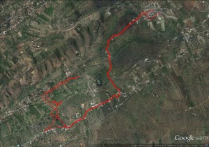
This is her map for today’s walk. We let you judge for yourself.
And to be sure, she calls them maps, and she criticises the ones you can buy as being out of date! GDR

So we have decided that the walk is actually not really worth the effort. So frustrating and angry we go back the way we came.
As we get back to the ridge, we look down into the valley. Where could we have gone wrong? We track backwards and soon find the track off to the right she talks about. It is immediately adjacent to a large white circular water tank. It would have been so easy to reference that. The path we took was not far away, we can still not understand where the fork in the road was. We can see the path leading up to and along the ridge on the other side of the valley, but no fork. It is so frustrating. GDR
This is our map. Slightly more helpful?
SM
Las pistas llanas excelentes para mi , seguro que no me cansaría de caminar.
Lo más bonito los acantilados.
Personalmente tengo la impresión que la señora del libro a echo pocas rutas, para describirlo correctamente.
La hemos criticado pero no nos ha contestado